Fact Sheet
Click here to download the PDF version.
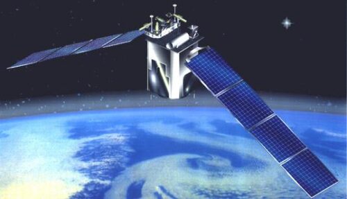
Thermosphere-Ionosphere-Mesosphere Energetics and Dynamics
TIMED Doppler Interferometer
TIMED Instrumentation
Experiment Overview
The TIMED Doppler Interferometer (TIDI) is investigating the dynamics and energetics of the Earth’s mesosphere and lower thermosphere. TIDI measurements allow us to obtain a global description of the vector wind fields, as well as important information on gravity waves, species densities, airglow and auroral emission rates, and noctilucent clouds. TIDI provides basic information about global winds. TIDI also contributes to the study of energetics.
Science Objectives
The TIDI interferometer (or Profiler) primarily measures horizontal vector winds along the Earth’s limb, with a vertical resolution 2.5 km and an accuracy that approaches ~3 m/sec under optimum viewing conditions. The TIDI design allows for 100% duty cycle instrument operation during daytime, nighttime, and auroral conditions. TIDI views emissions from the O2(0-0) Atmospheric band to determine the line of sight Doppler wind.
Description and Specifications
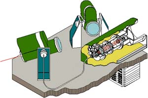
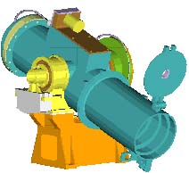
TIDI comprises three major subsystems: four identical telescopes, a Fabry-Perot interferometer with a CCD detector, and an electronics box. Light from the selected regions of the atmosphere is collected by the telescopes and fiber-optically coupled to the detection optics. The four fields of view are scrambled along with a calibration field input and converted to an array of five concentric circular wedges. This input then passes through a selected filter, then through a Fabry-Perot etalon, and is finally imaged onto a CCD via a circle-to-line imaging optic (CLIO) device.
TIDI System
| Mass: | 41.8 kg |
| Electrical Power: | 19.32 watts (orbit ave.) |
| Heater Power: | 11.0 watts |
| Data Rate: | 2494 bits/sec |
| Observations: | winds, temperatures, and density |
| Wind accuracy: | 3 m/s (line of sight) |
| Altitude Resolution: | 2.5 km |
| Spectral Range: | 550 – 900 nm |
| Lifetime: | >2 years |
Key Spacecraft Characteristics
| Orbital Altitude: | 625 km Circular |
| Orbital Inclination: | 74.1o |
| Total Spacecraft Weight: | 660 kg |
| Spacecraft Size: | Mid-Lite class |
| Launch Vehicle: | Delta II 7920 |
Electronics System
Hybrid Power supply
80C51 (UTMC) Flight computer
Data acquisition
CCD controller
Filter wheel/ shutters/ PWM heaters
Telescope servo amp
Calibration lamp power supply
Telescope Specifications
Off-axis Gregorian
Low scatter optics and baffles
Zenith gimbal
| Clear Aperture | 7.5 cm |
| Area | 44.2 cm2 |
| Angular FOV | 2.5o horiz x 0.05overt |
| F/number | 2.2 |
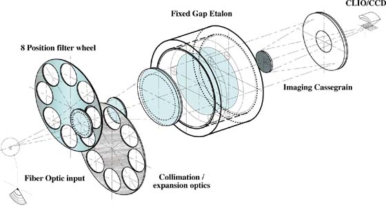

Profiler Specifications
| Fixed gap single etalon Fabry-Perot inferferometer | |
| 2 x 8 position filter wheel | |
| Circle to line image converter(CLIO) | |
| Passively Cooled CCD detector | |
| 5 x 32 Channels | |
| Clear Aperture | 7.5 cm |
| Plate Diameter | 10.5 cm |
| Gap | 2.2 cm |
| Finesse | 8.1-8.9 |
Principal Investigator
Dr. Aaron J. Ridley
University of Michigan
2455 Hayward St.
Ann Arbor, MI 48109
Phone: (734) 674-5727
Email: [email protected]
Dr. Timothy (Tim) L. Killeen, P.I. until 2008
Dr. Wilbert (Wib) R. Skinner, P.I. 2008-2014
Dr. Rick Niciejewski, P.I. 2014-2020
TIDI Key Parameter Summary
Tables 1 and 2 summarize the TIDI measurements for dayside and nightside modes, respectively, by listing the altitude range over which it is possible to obtain useful measurements from each emission.
Table 1. Dayside Measurements
| Measurement | Feature | Altitude Range |
|---|---|---|
| Vector Wind | O2 Atmosphere (0-0) P15 | 60 – 100 km |
| O2 Atmosphere (0-0) P9 | 70 – 115 km |
Table 2. Nightside Measurements
| Measurement | Feature | Altitude Range |
|---|---|---|
| Vector Wind | O2 Atmosphere (0-0) P9 | 80 – 105 km |
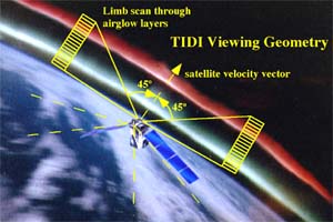
The TIDI telescopes perform limb scans through the terrestrial airglow layers throughout the satellite orbit. TIDI obtains these scans simultaneously in four orthogonal directions: two at 45° forward but on either side of the satellite’s velocity vector and two at 45° rearward of the satellite. These four views provide the measurements necessary to construct the horizontally resolved vector winds as a function of altitude along two parallel tracks, one on either side of the spacecraft. Each vertical scan consists of individual views 2.5° (horizontal, along the limb) by 0.05° (vertical, normal to the limb) in angular size. The vertical altitude resolution of the instrument is 2.5 km, but the altitude spacing between views is adjusted to yield a measurement vertical resolution of half a scale height throughout the limb scan. Each up/down acquisition cycle takes 100 seconds to complete, resulting in a nominal horizontal spacing between profiles of approximately 750 km along the orbit track. The exact time per vertical scan will depend on the mode being run and the integration or dwell time needed at each altitude step. Each up/down scan cycles through a sequence of filter tunings, selecting the optimal emissions to be viewed within each altitude range to allow neutral winds to be retrieved.
For more information on TIMED, access the JHC/APL Space Department website.